What “50 states” means, in plain English
What “50 states” means, in plain English ClubRive …
What “50 states” means, in plain English
TL;DR:
- The United States has 50 states with shared and unique powers.
- States are grouped into four Census regions and nine divisions.
- USPS sets the official two letter state codes used in addresses.
- Capitals are the seats of state government, not always the biggest city.
- Full table below lists each state, code, capital, and region.
The United States is a union of 50 states. Each state has its own constitution, laws, and elected leaders. The federal government handles national issues like defense and currency. States run schools, roads, public safety, and more.
Washington, D.C. is the federal district. It is not a state. The U.S. also has territories like Puerto Rico and Guam. This guide covers only the 50 states.
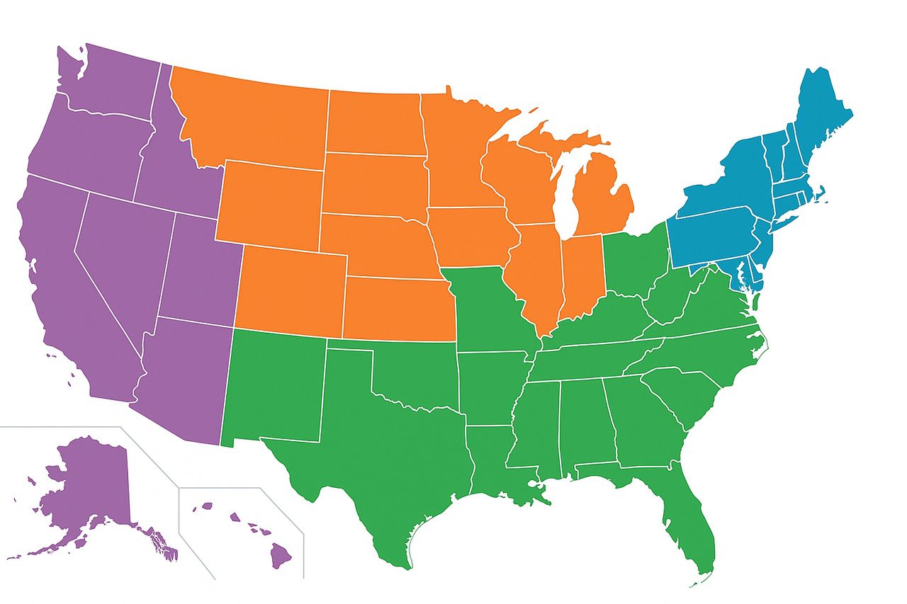
How the states are grouped
For statistics and maps, the U.S. Census Bureau groups the 50 states into four regions and nine divisions. These regions are Northeast, Midwest, South, and West. The divisions are New England, Middle Atlantic, East North Central, West North Central, South Atlantic, East South Central, West South Central, Mountain, and Pacific. This system is widely used by government and researchers. U.S. Census Bureau.
State abbreviations you will see everywhere
Every state has a two letter postal code, like CA for California and NY for New York. These codes are set by the United States Postal Service and appear on mail, forms, and many databases. USPS Postal Explorer.
Capitals, not always the biggest city
A state capital is where the legislature meets and the governor’s office sits. The capital is often not the largest city. For example, Sacramento is the capital of California, while Los Angeles is much larger. Britannica keeps a reliable list of capitals used below. Encyclopaedia Britannica.
Quick reference table
The table lists all 50 states with their USPS code, capital, and Census region.
| State | Code | Capital | Region |
| Alabama | AL | Montgomery | South |
| Alaska | AK | Juneau | West |
| Arizona | AZ | Phoenix | West |
| Arkansas | AR | Little Rock | South |
| California | CA | Sacramento | West |
| Colorado | CO | Denver | West |
| Connecticut | CT | Hartford | Northeast |
| Delaware | DE | Dover | South |
| Florida | FL | Tallahassee | South |
| Georgia | GA | Atlanta | South |
| Hawaii | HI | Honolulu | West |
| Idaho | ID | Boise | West |
| Illinois | IL | Springfield | Midwest |
| Indiana | IN | Indianapolis | Midwest |
| Iowa | IA | Des Moines | Midwest |
| Kansas | KS | Topeka | Midwest |
| Kentucky | KY | Frankfort | South |
| Louisiana | LA | Baton Rouge | South |
| Maine | ME | Augusta | Northeast |
| Maryland | MD | Annapolis | South |
| Massachusetts | MA | Boston | Northeast |
| Michigan | MI | Lansing | Midwest |
| Minnesota | MN | Saint Paul | Midwest |
| Mississippi | MS | Jackson | South |
| Missouri | MO | Jefferson City | Midwest |
| Montana | MT | Helena | West |
| Nebraska | NE | Lincoln | Midwest |
| Nevada | NV | Carson City | West |
| New Hampshire | NH | Concord | Northeast |
| New Jersey | NJ | Trenton | Northeast |
| New Mexico | NM | Santa Fe | West |
| New York | NY | Albany | Northeast |
| North Carolina | NC | Raleigh | South |
| North Dakota | ND | Bismarck | Midwest |
| Ohio | OH | Columbus | Midwest |
| Oklahoma | OK | Oklahoma City | South |
| Oregon | OR | Salem | West |
| Pennsylvania | PA | Harrisburg | Northeast |
| Rhode Island | RI | Providence | Northeast |
| South Carolina | SC | Columbia | South |
| South Dakota | SD | Pierre | Midwest |
| Tennessee | TN | Nashville | South |
| Texas | TX | Austin | South |
| Utah | UT | Salt Lake City | West |
| Vermont | VT | Montpelier | Northeast |
| Virginia | VA | Richmond | South |
| Washington | WA | Olympia | West |
| West Virginia | WV | Charleston | South |
| Wisconsin | WI | Madison | Midwest |
| Wyoming | WY | Cheyenne | West |
Regions and divisions cheat sheet
Use this quick mapping when you need finer groupings, like for data analysis or quizzes. Census divisions come from the U.S. Census Bureau.
- Northeast
- New England: CT, ME, MA, NH, RI, VT
- Middle Atlantic: NJ, NY, PA
- New England: CT, ME, MA, NH, RI, VT
- Midwest
- East North Central: IL, IN, MI, OH, WI
- West North Central: IA, KS, MN, MO, NE, ND, SD
- East North Central: IL, IN, MI, OH, WI
- South
- South Atlantic: DE, FL, GA, MD, NC, SC, VA, WV
- East South Central: AL, KY, MS, TN
- West South Central: AR, LA, OK, TX
- South Atlantic: DE, FL, GA, MD, NC, SC, VA, WV
- West
- Mountain: AZ, CO, ID, MT, NV, NM, UT, WY
- Pacific: AK, CA, HI, OR, WA
- Mountain: AZ, CO, ID, MT, NV, NM, UT, WY
FAQs for a global audience
Is Washington, D.C. a state?
No. It is a federal district. It is counted in some federal stats, but not as one of the 50 states.
Do territories count as states?
No. Territories like Puerto Rico and Guam are under U.S. sovereignty. They are not states and do not vote in the U.S. Senate.
Why do addresses use two letter codes?
Short codes reduce errors and speed sorting. USPS maintains the list used by mail and many systems.
Why do some states have small capitals?
Capitals were picked for location, history, or politics. They do not need to be the largest city. Capital names match the Britannica list used above.
Study checklist
Use this simple plan to learn all 50 states in a week.
- Day 1, learn New England and Middle Atlantic.
- Day 2, learn East North Central and West North Central.
- Day 3, learn South Atlantic.
- Day 4, learn East South Central and West South Central.
- Day 5, learn Mountain.
- Day 6, learn Pacific.
- Day 7, mix practice, quiz yourself, and map by memory.
Why it matters
The 50 states show how a federal system can balance local choice with national rules. If you study or work with U.S. data, you will see Census regions, state codes, and capital cities everywhere. Getting these basics right saves time and avoids mistakes. U.S. Census Bureau and USPS standards help keep that data consistent.
Sources:
- U.S. Census Bureau, “Census Regions and Divisions of the United States,” https://www2.census.gov/geo/pdfs/maps-data/maps/reference/us_regdiv.pdf, accessed 2025-09-08.
- United States Postal Service, “Appendix B: Two–Letter State and Possession Abbreviations,” https://pe.usps.com/text/pub28/28apb.htm, accessed 2025-09-08.
Encyclopaedia Britannica, “List of U.S. State Capitals,” https://www.britannica.com/topic/list-of-state-capitals-in-the-United-States-2119210, accessed 2025-09-08.


